In this section: |
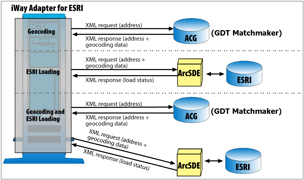
The iWay Technology Adapter for ESRI automates the processes of enriching data through geocoding and loading the enriched data into an ESRI database. Through the use of XML documents and business services, the adapter eliminates the need to write custom code to perform these tasks. Depending on your needs, it can perform geocoding and data loading separately, or it can perform both functions within a single service.
Though you can set up any directory to hold the spatial information (that is, the GDT data), the iWay Technology Adapter for ESRI refers to a directory named ACG for this purpose.
For geocoding purposes, the iWay Technology Adapter for ESRI works with GDT Matchmaker.
The iWay Technology Adapter for ESRI works with ArcSDE APIs from ESRI.
The adapter interfaces with the ESRI database through the ArcSDE spatial data server. This server is the gateway for storing, managing and accessing spatial data in the ESRI database and is key to managing a multi-user spatial database.
To illustrate these processes, the following image shows the flow of XML request and response documents for geocoding function, the ESRI loading function, and the combined geocoding and ESRI loading function.
One application of GIS would be to analyze crime patterns so that a community could evaluate a prevention strategy and estimate their need for police resources. The police department typically has a database of crime information that includes, among other items, the type of crime, the date of the crime, and the address where the crime occurred. To utilize this data in a GIS, a crime location needs to be enriched with latitude and longitude coordinates and then delivered to the ESRI database where it is available for mapping and analysis.
The iWay Technology Adapter for ESRI sends the crime location data to a geocoding service in an XML request document and retrieves the latitude and longitude data for that location in an XML response document. The adapter can deliver that data to the ESRI database using the ESRI Load function through an XML insert request document. The adapter can also perform a delete, an update, or a query of a record in the ESRI database.
Without the adapter, you would have to write programs to match your address data with geospatial data found in another application, retrieve that information, and then move it to the GIS database. The adapter automates these functions for you.
See Using the Adapter - A Scenario, for an illustration of geocoding and ESRI loading applied to crime data.
The iWay Technology Adapter for ESRI supports the following data types:
This section lists known limitations for the iWay Technology Adapter for ESRI.
| iWay Software |